Geophysics
Mernda sports facility geophysical investigation
PROJECT: Mernda sports facility geophysical investigation
CLIENT: Stantec
THE SITE
Located in the City of Whittlesea, approximately 30 kilometres north-east of Melbourne, lies the rapidly developing suburb of Mernda.
A proposed development of a state of the art regional sports and aquatic facility will assist in servicing this growth suburb and its surrounds, to accommodate the various health and wellbeing needs of its diverse community.
THE CHALLENGE
The proposed 24ha site is known to have shallow basalt rock with numerous outcrops visible at the surface. Basalt rock is an extrusive volcanic rock which can be several times stronger than concrete, creating difficulties in construction projects.
The presence of basalt rock within the site area had the potential to considerably influence the design and construction methods of the project. An informed understanding of the subsurface conditions of the area was critical to the design phase of the project.
The project engineers, Stantec, commissioned a geotechnical investigation to identify soil and rock mechanics using boreholes and test pits at selected points, to assist in the development of the engineering designs for the project site.
The facility will incorporate an Olympic sized swimming pool, which will require significant excavation on the site. The conceptual design of the facility indicates the position of the pool within the site; however this would be dependent on the depth of bedrock.
To minimise the project costs and construction timeline, mapping the near surface bedrock would be paramount to the overall development.
THE SOLUTION
MNG SubSpatial conducted a geophysical investigation to accurately map the level of basalt bedrock throughout the proposed site. These results would form part of the broader geotechnical scope of the site classification package.
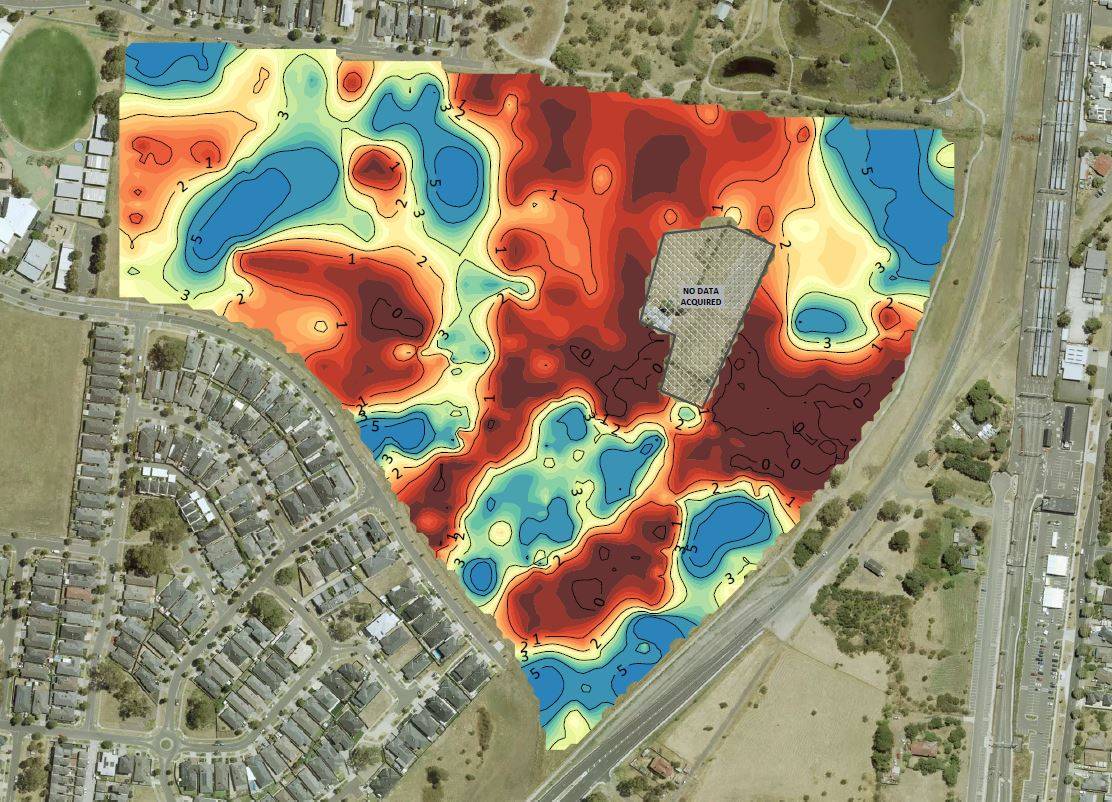
A Multi-channel Analysis of Surface Waves (MASW) geophysical survey was conducted along a series of transect lines across the project site to profile the basalt bedrock along the line.
A multi-channel seismograph records the seismic wave signals along a geophone array, which is then used to evaluate the relative shear strength of subsurface materials and depth to the bedrock below the surface. GPS measurement along the transect lines are used for position and elevation and to create a 3D plan.
MNG SubSpatial elected to increase the number of geophysical transects over the proposed pool location to provide greater detail in this area to the bedrock.
The results from the geophysical investigation were compiled into a series of plans including MASW profiles along the transect lines, plus a set of contour plans with topography, basalt bedrock and depth below surface to the basalt bedrock. The geotechnical sites were also plotted.
THE OUTCOME
Results from the geophysical investigation have been welcomed by Stantec to inform their design of the proposed sports and aquatic facility. The basalt bedrock is undulating across the site from the surface to approximately five metres below ground level.
An area large enough to accommodate the Olympic sized swimming pool has been identified with an average depth to bedrock of 3.5m enabling the costs to be regulated during the construction period.