Engineering Surveying, Geospatial Data Management & Analysis, Laser Scanning (LiDAR), Precise Control & Specialised Surveys
Demanding tolerances in tight challenging environments
PROJECT: Stirling Bridge upgrade | Fremantle, WA
CLIENT: Main Roads Western Australia & AECOM
PROJECT BACKGROUND
The Stirling Bridge in Fremantle is the primary bridge connecting the southern and northern suburbs down the Western Australian coastline, alongside Fremantle Harbour. The bridge is paramount to traffic and freight logistics in the greater Perth region, as the old Fremantle Traffic Bridge located to the west has almost reached end of life.
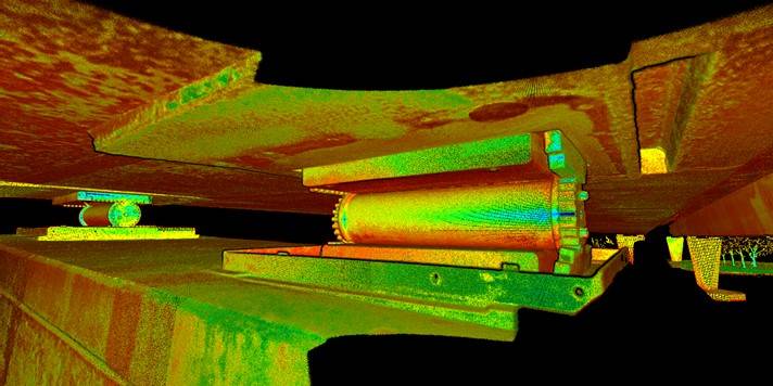
The 415m long, concrete bridge spans the river at a height of almost 10m above the water and plays a pivotal role in connecting the Fremantle port with inland freight distribution points. The bridge is supported by five piers, each with two columns, between the north and south abutments. The 15m wide structure sits on a set of steel roller bearings, atop each column, with a finger joint in the north abutment to allow for expansion and contraction.
Opening in 1974, the Stirling Bridge is over 50 years old and today handles over 5,000 trucks and 30,000 cars every day. Due to its age, however, the differential shrinkage along the bridge has reached a point where the steel roller bearings are approaching their maximum extension across the bearing plates.
To replace the bearings and plates, it was imperative to have an accurate 3D model of each roller bearing and respective bearing plates.
Main Roads Western Australia and AECOM engaged MNG to provide support for this critical project.
CHALLENGES
MNG was challenged to survey each bearing installation accurately and safely, without disrupting traffic movements across a main
arterial highway. This is because road closures are a safety hazard and expensive, which means they typically need to be done at night to minimise traffic disruptions.
SOLUTIONS
Access from the top of the bridge was not considered viable and this alleviated the need for any road closures and traffic disruptions.
In consultation with Main Roads Western Australia and AECOM (the consulting engineer company that designed enhancements for the bridge), MNG recommended laser scanning as the most efficient and accurate solution.
MNG opted to use its Leica P30 high-definition laser scanner as it provides best in class capture for speed and accuracy, enabling an accurate 3D model to be created for each roller bearing.
In planning the project, the MNG team decided to scan the bearing from multiple points around the top of each column, and each scanning point would need to be accurately surveyed so that all scans could be consolidated to one model for each bearing.
It took more than 60 scanning points to capture all roller bearing installation points across all five piers and abutments of the Stirling Bridge.
The logistical challenge of scanning at the top of each column was overcome with the provision of a barge equipped with an elevated work platform. The survey team utilised a prefabricated bracket to support the scanner, to ensure it was mounted securely at the top of each column. This provided a safe work environment for the surveyors and their support team. Boating movements along the river were also controlled to minimise disruptions.
Using a high-definition scanner secured atop the piers above the river, enabled the survey to be completed over a two-day period. Additional ground control was also completed in this time.
OUTCOMES
A critical aspect of the project was for the new components to be manufactured to exact tolerances ensuring they fitted in position, without any delays.
MNG’s survey produced an accurate and comprehensive 3D model of:
• all roller bearings;
• edge of all top and bottom bearing plates;
• bolt centres;
• outline of the top of piers; and
• the outline of soffit of the bridge deck, directly above the bearings.
This provided vital, detailed information of the bearing installations, to millimetre tolerance, which enabled the manufacture and machining
of the new components.
New bearings were successfully installed, safely, without disruptions to traffic and the project was deemed a success, thanks (in part) to MNG’s expertise and commitment.