Utility Locating & Mapping
Fremantle Fishing Boat Harbour Upgrade
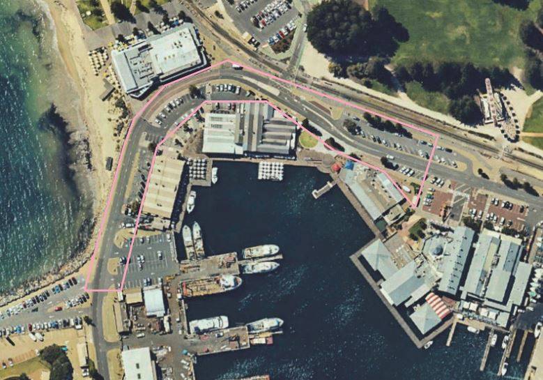
PROJECT: Fishing Boat Harbour Survey and Underground Service Investigation | Fremantle, WA
CLIENT: Department of Transport
THE SITE
The Fremantle Fishing Boat Harbour originated when a 300-metre breakwater was first constructed was in 1919 to provide much needed anchorage for fishing vessels.
Over the years the port continued to be developed, most notably during the 1980’s to accommodate the America’s Cup Challenge. Today the busy working port serves the fishing industry, and public interests with restaurants, tourist attractions and accommodation, making it a popular destination for locals and tourists alike.
THE CHALLENGE
As part of the $5.5 billion WA Recovery Plan, replacement jetties, amenities buildings, and new pen holder facilities are planned. To support these new structures significant upgrades to the ageing electrical infrastructure are required. With the last upgrade to the site dating back to 1985, the intended improvements would provide a more reliable electrical supply for tenants, increased capacity to power existing and future operations and enhance safety conditions for maintenance crews.
In order to prepare detailed engineering designs for the electrical infrastructure the Department of Transport (DoT) required an accurate detailed survey of the surrounding buildings and harbour area, inclusive of above and below ground service information, across the 18ha site. DoT stipulated that the survey should be undertaken in a safe, non-intrusive and efficient manner and provide the information in the specified formats.
The subsurface utilities are located within the roadways sitting atop of the breakwater surrounding the harbour. These areas are comprised of a large percentage limestone and reclaimed material which are typically highly compacted and a challenging environment for Ground Penetrating Radar (GPR) in soils of this nature.
With the site being a busy, fully operational port, tenant and public safety was a key consideration. The roadways are within high traffic, vehicular and pedestrian, corridors. It would be imperative that all detail be captured in a safe and timely manner, to ensure minimal disruption to roads, public areas and establishments.
THE SOLUTION
In consultation with DoT, MNG developed a program schedule to achieve the desired outcomes. An integral component of the program was to access service pits which would be in done conjunction with the client’s maintenance contractor. Progress reports were delivered to DoT on a weekly schedule to inform of progress and any unexpected challenges within the project. Working with the maintenance contractor MNG was granted predetermined access to confined areas such as service pits, trenches, and electrical switch-rooms to locate the multitude of services. This work was conducted using mobile, non-invasive equipment including Ground Penetrating Radars (GPR) and Electromagnetic Induction (EMI). Where necessary, MNG recommended services be potholed to obtain a Quality Level-A identification of the service.
In order to minimise disruptions to leaseholders and patrons across the site all surveying and locating activities were undertaken outside peak hours. Utilising a two-person survey crew with a robotic total station, plus a single locator ensured the project was undertaken in an expedient and safe manner. This also minimised the use of Traffic Management which further ensured least inconvenience to the general public.
Safety is paramount to DoT and MNG alike and all site personnel are accredited with required Occupational Safety and Health inductions, plus the mandatory Take5 risk assessments prior to commencing work.
Signage and hard barricading was installed to ensure there was a clear separation between operational equipment and the public at all times.
THE OUTCOME
Information gathered from the feature survey formed the basis for the design process by accurately identifying all integral components of the surrounding area. As part of the scope of work, MNG identified any interferences and potential clashes throughout the site.
Detailed survey plans, including photographic records were compiled and delivered to DoT in the specified formats. This is of significant benefit to the client, helping to lower material waste, reduce installation problems and avoid asset strike in the construction phase of the project. MNG were able to successfully deliver all requirements for this project.
This information will be utilised in the development of detailed engineering designs, as part of the upgrade to high and low voltage electrical infrastructure at the Fremantle Fishing Boat Harbour.